
The St. Lawrence Project
Section 4
Although Ontario Hydro's first offer was on a 'take it or leave it' basis, late in 1954 they came up with a new plan, offering to relocate as many houses as could feasibly be moved. As always, there was a catch. Homeowners would have to negotiate their property value on a one-to-one basis with Ontario Hydro. Some came out ahead and others felt they had been taken. Nevertheless, 152 homes in the village of Iroquois were saved and relocated to a new Iroquois village about two kilometres north on higher ground, also home to the new Iroquois dam and lock. The destroyed section of Morrisburg was replaced by a new development on the north side of the village. All told, relocation affected 6,500 people, 531 homes, 225 farms, 17 churches and 18 cemeteries, which included the re-internment of more than 2,000 bodies. Those buildings that couldn't be moved were demolished or burned down.
 Building the new town of Iroquois
Ontario Hydro's plan included an ambitious waterfront rehabilitation program that added nine parks and beaches between Lancaster and Iroquois. A few of the more historic buildings were moved to Upper Canada Village, near Crysler Park, a newly-created pioneer and historical theme park, which remains a popular tourist attraction. A new Ault Park was created to replace the park on Sheek Island, donated by Levi Addison Ault in 1914. In 1955 the province of Ontario created the St. Lawrence Parks Commission whose mandate is to manage and promote the various historical and recreational resources stretching along the St. Lawrence from Kingston to the Quebec border.
It was 8:00 am on July 1st when the historic event began to unfold. It started with the sound of a distant muffled blast, the sound of 30 tons of dynamite tearing open the cofferdams that had been holding back the water over the last four years. Although many had expected a huge wall of water to come gushing in, it didn't happen like that at all. The water began as a trickle, flowing slowly and steadily, gradually covering the foundations and roads of the historic villages. By the second day, the water had made its way to Moulinette, Wales and Dickinson's Landing. The following day Aultsville, old Iroquois and the east side of old Morrisburg were flooded. By day four, all the villages, islands and farmlands were laying at the bottom of their watery grave.
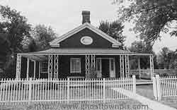 Michael Cook home at Upper Canada Village
Although the villages have been gone for more than 50 years, they continue to attract a considerable amount of attention, probably much more so than when they actually thrived. Divers from all over search underwater for remnants of old locks and foundations. In 1977, a group of former residents founded the Lost Villages Historical Society, a group dedicated to preserving the history of the lost villages. Their museum, located at Ault Park, contains numerous artifacts, a large photo collection and a number of beautifully restored heritage buildings, which originated either from the villages or from the surrounding area.
Memories and images of the villages themselves remain frozen in time. In reality they were probably not much different from the many other small riverside farming hamlets that continue to dot the shores of the St. Lawrence.
During the 1950s and early 60s, casualties of industrial progress were viewed as being an unfortunate but sometimes necessary by-product, particularly when society in general was viewed as being the principal beneficiary. By the late 1970s that line of thinking had shifted somewhat as people began to focus their attention on the past and on whether the sacrifice of many of our historical symbols and structures was worth the price. However given the need for greater power resources and better transportation routes for shipping, it seems likely the same decisions would be made today.